IP3 Technical Integration
This section gives an overview of the goals, design process and development, and the projects students are working to develop and deploy the Puerto Rico Student Led Test Bed radar network.
IP3 Goals. The Puerto Rico Student Test Bed (STB) serves to introduce students to system level engineering, develop the foundation for a test bed in Puerto Rico and explore high-density DCAS networks for precipitation estimation and mapping while advancing CASA’s strategic planning and goals in developing low infrastructure radar networks. The goals are as follows:
• Analyze, Develop and Deploy solar powered “Off-the-Grid” Radars (OTG)
• Develop theory of operation of high-density, energy balanced radar
• Construct a 4 node test bed based on proof of concept design
• Produce reflectivity and rainfall estimate products in test bed coverage area
• Deployment of a Sit & Spin Radar System
• Construct a Sit & Spin network in Western Puerto Rico focusing on student education
• Develop “back end” systems for OTG, Sit & Spin and future test bed deployments
• Develop grid services implementation of radar processing and storage
• Establish suitable radar locations based on a social, climatological and physical vulnerability assessment
IP3 Structure and Schedule. The Student Test Bed radar network schedule is divided into two main stages: the sub-systems design (sensing nodes, network control, weather algorithms, etc.) and the system integration and operation process. Two different radar configuration sub-systems are being designed and tested. These are the high power transmitter magnetron based radar (PR1 node) and the low power Off-The-Grid (OTG) radars. The first OTG radar in Puerto Rico is being constructed and modified to support OTG operation by students at UPRM, and modifications are being performed to improve its sensing capability. Set up of a network of 4 radars is expected by Fall ‘09. PR1 was completed and installed at the rooftop of the Stefani building of UPRM, the system (hardware and software) is operational and rainfall data is being collected. Assessment of data quality and validation is being performed by UPRM students. A third class of radar (PR2) was donated to the UPRM students by EWR and was installed in the northwest part of the island during the summer of 2007, and rainfall data has been collected. With the radars operational, we will be able to test the complete system and make the necessary changes in hardware and software to meet the target goals and capabilities. In addition, the PR2 radar will serve as a validation node for the PR1 and OTG radars.
System Design Process. The Puerto Rico CASA Student Test Bed radar network is an engineering test bed completely designed and managed by students ranging from undergraduate to PhD levels from the CASA partner campuses: University of Massachusetts Amherst (UMass), University of Puerto Rico Mayagüez (UPRM), Colorado State University (CSU) and University of Oklahoma (OU) and outreach partner: University of Delaware. Bi-weekly intercampus system requirements meetings are organized where students share their ideas, design and work in their respective research areas and discuss the agenda presented at the time. Meetings between students in their respective campuses are also organized. The complexity of the design makes the STB system engineering process a big challenge for the students, where an important goal is the student’s education.
System Architecture. The proposed IP3 system architecture is shown in Figure 42.
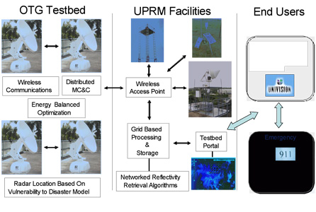
Figure 42. IP3 System Architecture.
Components of the system architecture can be classified as sensing nodes, network communications topology, software architecture, grid-based processing and storage, and end user integration. A short description of each of the components follows.
Sensing Nodes. The radars making up the test bed will be based on magnetron marine radars as shown in Figure 30. Two classes of radars are under development by students and the EWR radar company donated a third class to the STB.
Network Communications Topology. Communications for the OTG radar network will be handled by 802.11b wireless ad-hoc networking between the radars and an access point. Communication between the radar located on the roof of the UPRM Stefani Engineering building (PR1) and the UPRM access point will be based on 802.11g infrastructure. Data transport and radar control for the PR2 EWR node is performed using a service provider broadband connection. Once the data is located at the university local area network (LAN) any further data transport will use UPRM Ethernet links.
Software Architecture. A dynamic resource control algorithm will be developed to manage the resources available in an OTG network. Energy resources and bandwidth availability put a constraint on the ability of the network to sense the atmosphere and communicate the information. Data collected by the individual radars may be requested by multiple users interfacing at the edge of the network. Users may be connected to the network through one or more nodes. An OTG network will need to be dynamically managed to efficiently use the locally generated energy in order to sense the atmosphere, process the collected data and transport the data while meeting end user requirements.
A decentralized energy aware dynamic resource control algorithm is being developed by extending the CASA IP1 architecture and algorithm to the energy-constrained case. The IP1 architecture and algorithm assigns utility functions to individual user requests and optimizes radar scanning strategy based on tasks generated by the system. Currently, the algorithm operates in a central location and issues scan strategy commands to each of four radars. The optimization does not consider energy or bandwidth when optimizing the system.
Rather than operate as a centralized algorithm, the proposed architecture decentralizes the algorithm by calculating individual node tasks separately for each node, at the respective node. In addition to moving node task computation to individual nodes, neighboring radars will be considered to be users of the system and will issue their neighbors’ request. Neighbor radars’ requests would include data transport to the end user, data processing such as merging or compression, and scan requests. Each of these requests would be assigned as a task to the radar with a corresponding utility function. These tasks would be included during node task calculation along with user requests. Energy and bandwidth will be included in the task cost functions as penalties. The cost functions will be determined based on the system energy model currently being developed.
Grid-Based Processing and Storage. A grid portal interface (STB grid portal; Figure 31) has been implemented to ensure a transparent mechanism for accessing resources and grid services. The manipulation of processed and raw data as well as the visualization of weather information is available via grid portlet implementations. An automated set of shell scripts were developed for the following tasks: deploy a visualization of the last recorded data of the PR1 radar, transfer radar raw data using a secure protocol between the STB radar network nodes for data processing, run image processing sequences to present a better radar visualization, and obtain web mapping information from Google to be added to the maps. Radar data from PR1 can be downloaded through the STB portal and illustrated using the Google maps portlet application inside the STB grid portal. As part of the grid portal interface’s main features, an algorithm for data transformation and format conversion was developed. The grid portal improvements consist of two new main portlet interfaces. The first one includes the visualization of the real time data of the PR1 radar node using Google map technologies. The second interface allows management of the raw data, providing to the user the option of transforming the raw data to reflectivity units (dBZ), and to apply the conversion algorithm to obtain the data in the NetCDF format for easier distribution. In addition, the locations and data of the 16 weather stations from the NOAA Crest UPRM Data Center can be obtained directly from the Google maps portlet as shown in Figure 43. Data from PR2 and the OTG radars will be added to the STB portal portlets once it is available.
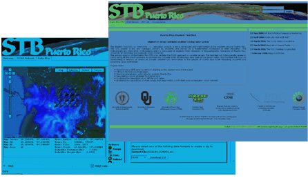
Figure 43. STB Grid Portal Interface
Student Test Bed End User Component. The objective of the end user integration is to incorporate end users’ needs into the DCAS system design and implementation. End users provide input through the design of the system for it to be capable of sampling data that fulfills their needs. Users are then able to request and use data from the STB radar network for their intended use in research, emergency management or public intended forecasts.
The end users’ group of participants is composed of government agencies, CASA core academic institutions, local media news, emergency management agencies and the public in general. From the end users’ group, the government agencies, the academic institutions and the local media are the only ones allowed to request data from the system and to provide feedback for design modifications. Emergency management agencies and the public are indirect end users of the STB radar network, and they will receive data already processed and illustrated as weather forecasts and prediction models through either the government agencies or the local media news.
Students at UPRM have been in contact with the National Weather Service (NWS) Weather Forecast Office (WFO) at San Juan and conversations have demonstrated interest from NWS WFO in the STB network radar data. Furthermore, NWS WFO provided UPRM CASA students with the NOAA NWS Weather Event Simulator (WES) radar software and the data feed for the TJUA WSR-88D (located at Cayey, Puerto Rico). This software will help students at UPRM to learn the products of the operational TJUA WSR-88D weather radar. In addition, the data from TJUA will be used in the validation process of the STB radar network.
Students are developing two tools to aid emergency managers with their decisions in hazard weather event situations. A real-time Flood Alert System based on a distributed hydrologic model is being developed at UPRM and a Disaster Decision Support Tool that combines demographic, socio-economic, physical, and infrastructure data in a single platform is being developed at the Disaster Research Center at UDel.
Student Test Bed Research in Social Vulnerability. The social impact of the technology developed by CASA is vital for the success of this Engineering Research Center. In order to develop a technology that meets the needs of the end-user community, which includes the National Weather Service, emergency management agencies, the media, researchers and the general public, CASA has taken the challenge of understanding the needs of the end-user community and incorporating them into the radar system design and implementation. As part of the Puerto Rico Student led Test Bed, doctoral student Jenniffer Santos-Hernández has continued to develop a more holistic quantitative measurement of vulnerability in Puerto Rico. This research explores issues related to development, vulnerability and hazards in the coastal regions of Puerto Rico. We explore how the economic transformation of the island and the associated policy changes facilitated a population shift toward the coastal zone and how the strategies employed have been insufficient to address the historical issues of poverty and lack of employment opportunities for the local population. Using geo-coded socio-demographic data at the block group level from the U.S. Census of Population and Housing, and data on storm surge flooding, an additive index was created to examine changes in the social vulnerability of coastal communities from 1990 to 2000. The index was calculated for all coastal municipalities in the island. Poverty appears to be a driving factor in the accumulation of other characteristics of disadvantage; communities located around de-industrialized areas and public housing projects have the highest social vulnerability scores.
As part of this effort, Santos-Hernández developed the Disaster Decision Support Tool (www.udel.edu/DRC/DDST) and findings of our research, as well as other pertinent data obtained from a number of federal and local government agencies is available to end-users in Puerto Rico.). It is important to highlight that a tool with such capabilities did not previously exist for Puerto Rico. Emergency management officers are now able to visualize the risk of the population in their jurisdiction, the infrastructure, aerial imagery, and the socio-demographic composition of the population in those areas. In May 2008, Jenniffer Santos-Hernández was invited by the State Agency Emergency Management Agency to offer a training workshop for emergency managers at the PR Annual Emergency Management Conference. At this point we are incorporating the necessary extensions to facilitate availability of the data generated by the CASA STB radars.
Santos-Hernández’ dissertation will explore whether FEMA’s Community Emergency Response Teams (CERT) are in place in those communities in the Puerto Rico test bed with the highest social vulnerability scores. Her research will examine the satisfaction and recommendations of community leaders and other key informants with FEMA’s CERT program, aimed at educating residents about disaster preparedness and basic response skills. Her research will explore community and kinship networks, norms, culture, and socio-demographic characteristics, and inform how the CERT program is implemented and perceived by community residents. Findings of this research will provide an assessment of the CERT program and will identify potential ways to enhance it by incorporating the perception and recommendations of the community. In order to further these research efforts, Santos-Hernández will be collecting data in Puerto Rico during the Fall of 2009.
Understanding the End-User Community of the Puerto Rico Test Bed. To better understand the behavior, access, needs, and perceptions of the end-user community, and the impact of the CASA technology in Puerto Rico, we are conducting in-depth interviews with key personnel from NWS, emergency management offices, and media partners similar to those conducted in the IP1 Oklahoma Test Bed. While the sample of the Student Test Bed Research will be much smaller and limited to key informants (approximately twenty-five participants), this research will allow us to have a preliminary understanding of the end-user community in Puerto Rico, and compare it to that of the state of Oklahoma. While this initiative will allow us to understand the end-user community in Puerto Rico, it has also provided an opportunity for students to enhance their research and data collection skills. Preliminary findings show significant differences in the way that emergency managers receive, interpret, and use radar data. Moreover, our research highlights important differences in terms of the role of emergency managers, the levels of training, access, preferences, and use of information sources, and the organizational features of Puerto Rico’s Emergency Management Agency (State Agency for Emergency Management and Disaster Administration-AEMEAD). In addition, CASA radars are expected to be very helpful to the National Weather Service as they describe it as filling ‘the void’ in terms of data for the Western region of Puerto Rico. Additional interviews will be conducted during Fall 2009.
Radar Data Validation. As part of the Puerto Rico Student Test Bed, a number of weather stations and disdrometers were installed in the domain of the radar network with the objective of correcting and validating radar data and retrieval of rain rate-reflectivity (Z-R) relations. This includes 3 weather stations donated by Vaisala, which have the capability of measuring rainfall, and two disdrometers for the estimation of drop size distributions. In addition, the NOAA Crest UPRM Data Center’s 16 extra weather stations will be maintained and used by the students in the test bed for the validation process. All of the stations are located in Western Puerto Rico at locations inside the coverage range of the PR1 and PR2 radars.
|