Wind Product Evaluation: Tracking Tornadoes Down Streets
In previous years, network scan strategy has been primarily developed through reflectivity contours. However, since last year, the scan strategy has been developed for Doppler wind retrieval. The new system was evaluated through the spring experiments. Accordingly, the coordinated Doppler wind scan forms an integrated part of the closed-loop DCAS command & control system. The vector wind product serves as a critical piece of add-on information to forecasters and emergency managers. Especially, the high-resolution wind field, acquired close to the ground with the DCAS paradigm, will improve the detection of tornado touchdowns and the tracking of the rotation centers. A confirmed EF-2 tornado case observed by the IP1 network on the evening of May 13, 2009 (CDT) clearly demonstrates this capability. The storm entered the network from the north and later on spawned a tornado that affected the towns of Gracemont and Anadarko, Oklahoma during the evening. The DCAS system captured this event from the beginning and tasked KCYR and KSAO to perform Dual-Doppler optimized wind scan. By 0200 UTC, a strong low-level circulation had formed and by 0215 UTC low-level rotation was observed in the dual-Doppler region of KSAO and KCYR, about 10 km north to Anadarko, Oklahoma. A damage survey on the following days confirmed an EF2 tornado on the ground approximately between 0220 and 0245 UTC. The couplet of hook echo and wind rotation was clearly seen from the real-time display. The wind velocity was synthesized from 250 m AGL and up, helping the weather service issue the tornado warning and confirm the tornado touchdown. After the event, the vorticity was computed from the horizontal wind fields and its peaks were used to locate the damage path. The tornado path tracked by the IP1 network matches very well the damage path from the ground survey, which spanned over a 12-km swath during 18 minutes. This offline evaluation proves the capability of DCAS observations for tracking tornadoes down to the street, with higher resolution and lower level coverage, and the potential to improve the siren-blow warnings.
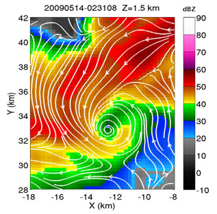
An example of horizontal cross section plot with the horizontal wind field overlaid on the top of radar reflectivity shows the mature stage of the tornado on 0231 UTC, exhibiting a clear hook echo and a well formed circulation. The wind fields were plotted as streamlines to show the rotation center.
|