CASA data confirms forecaster conceptual models for convective weather development
Conceptual models developed by meteorologists describe the evolution of different severe weather hazards, such as supercell thunderstorms, in terms of their important meteorological features and physical processes. As part of the severe weather warning process, National Weather Service forecasters are trained to recognize and interpret these meteorological features in radar data, currently NEXRAD, to identify and predict tornadoes, hail, or straight line damaging winds. Eighteen NWS forecasters who analyzed CASA data indicated in interviews and debrief questionnaires that CASA data confirms conceptual models of convective weather development, and at the same time, provides higher resolution and/or low-level detail on meteorological features often absent or difficult to interpret in NEXRAD data. For example, for squall lines (lines of thunderstorms that can extend for several hundred miles), CASA data provides critical high-resolution, low-level detail at the leading edge of the squall line typically not seen in NEXRAD data at distances great than 100km. These include rear inflow jets, the ascending branch of a squall line, gust fronts and secondary surges, all which occur at low-levels. Each of these features may result in damaging winds at the surface. In addition, CASA's overlapping radar coverage permits more detailed observations of the wind direction and speed for these features. With CASA data, forecasters may directly observe surface winds to identify geographically specific locations of microbursts, straightline winds, potential tornadic development for communications and warning to emergency managers and the public. The NWS forecasters were participants in the National Oceanic and Atmospheric Administration's (NOAA) Hazardous Weather Test Bed.
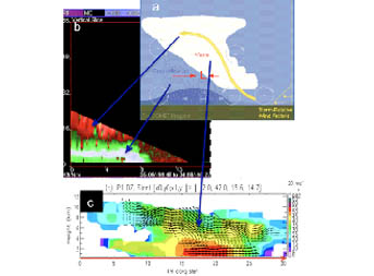
a) Squall line conceptual model used for forecaster training showing rear inflow jet, ascending branch (in white with yellow arrow) and cold pool in blue b) Vertical slice of 5/30/07 squall line in CASA data shows the rear inflow jet (white, 70 mph winds) and likely downburst where it reaches the ground and ascending branch in red c) Multi-Doppler vertical view of 6/20/08 squall line shows ascending branch, and cold pool with damaging straight line winds at the surface.
|